Village History / What to See
Early settlers
The people who originally arrived in the Hathersage area would have found the valleys mainly covered in trees with rivers and streams running down the wooded slopes, making them boggy, dark and dangerous places in which to live. The first settlers who chose to stay in the area therefore chose to build their homes on the higher ground, the area around these houses later being cleared for growing crops. The nomadic life of the roaming hunter-gatherers had changed, they had become farmers.
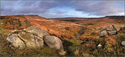
Burbage from Carl Wark (Stephen Elliott)
The first signs of any community life in the local area are to be found just south of Stanage Edge, a massive gritstone edge north of the village, where there are the remains of Bronze Age circular stone-walled huts or ring-banks, cairns and field systems, just east of Dennis Knoll. This is only 4km from the hillfort known as Carl Wark, where there is a massive stone wall believed to date from the Iron Age.
In the Romano-British period, people settled further down the slope from Dennis Knoll, close to North Lees. They led a very hard life, living in stone huts as their predecessors had done. This site, known as The Warren, is considerably lower than the earlier one although both are close to a fresh water supply – as necessary to them then as it is to us today. Very little is known about the Hathersage area and its inhabitants during the Dark Ages, although it is likely that there were scattered farms here, rather than houses clustered in a village.
The next recorded history of the village is in the Domesday Book where “Hereseige” was “the land belonging to Ralph Fitz Herbert” occupying “land for two ploughs” which had been under the care of “Levenot and Leuric” before the Conquest. It is thought that the semi-circular embankment, known as Camp Green, to the east of the Parish Church was built around this time. Signs of early strip farming can be seen in fields around the village, and people farmed the land in this way for hundred of years from the Saxon period onwards.
Parish Church
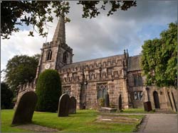
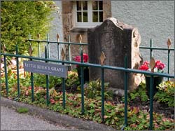 The Parish Church, dedicated to St. Michael and All Angels, was in existence shortly after this time c1125AD. Little John’s Grave is believed to be sited in the churchyard as, during the 13thC, the legendary Robin Hood was reputed to be living in and travelling through the area. At that time Sherwood Forest stretched much further north than at present and many local features are named with a Robin Hood connection – Robin Hood’s Stoop, Little John’s Flight, Little John’s Well, Robin Hood’s Well, Robin Hood’s Cave.
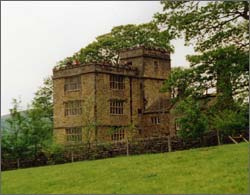
North Lees Hall (Barbara Wilson)
The present church building dates mainly from the 14thC. Many additions to the church were made during the next few centuries by a local family – the Eyres. Robert Eyre came from Thornhill, further along the Hope Valley, and married a local heiress, Joan Padley, who brought with her dowry many valuable lands in the area. The family prospered, several members becoming High Sheriffs of Derbyshire and they built many fine houses such as Offerton, Highlow, Hazelford and North Lees, all of which are still standing today.
Industry
The local stone had been found to be suitable for making millstones and grindstones, and quarries had been set up on surrounding gritstone edges since at least the 15thC, the finished stones being transported far afield by horse-drawn vehicle to navigable rivers such as the Trent, where they were transferred to barges. Lead had long been smelted on the hills above the village in wood-fired boles, but by the 18th century, coal-fired “cupolas” were being used, as on Callow Bank, north-east of Mitchell Field Farm.

Barnfield Works ((Stephen Elliott)
The introduction of water-powered mills to the area brought many changes. The streams which flowed into the village from the hills around provided an ample supply of water in the winter and small reservoirs, typical of the one used to power Dale Mill, were built to retain the water for use when the water supply was lower than usual. The mills were used at that time for wire-drawing, brass button manufacture and papermaking.
The mills, the quarries and smelting brought an increase in the local population including many trades-people. Agricultural work became less popular at this time as more jobs became available in industry.
Transport became important and improved roads were necessary to bring in the raw materials and to take out the manufactured goods. The pack-horse trains arrived from Cheshire with pottery and salt, the routes continuing onwards towards Chesterfield and Sheffield. Many streets are named as a result of this trade – Saltergate Lane in the neighbouring village of Bamford, Saltergate in Chesterfield, Psalter Lane in Sheffield and our own Jaggers Lane – a jagger being the man in charge of a team of pack-horses. Pack-horse routes are still to be seen in many areas locally.
19th Century
Quarrying continued into the late 19th century, the focus being on producing dimensional stone for building, and making grindstones for the metal trades.
Steam took over from water as the energy provider in the mills in the mid 19th Century, bringing increased reliability but more pollution. In total five mills were in use at that time, three new ones having been built to produce needles and pins of various types. Needles, in presentation boxes, produced at Barnfield Mill were on show in the Paris Exhibition in 1851. Two mill chimneys still stand today as monuments to this particular era of our village history. In their many years of operation the mills had produced items as varied as pearl buttons, gramophone needles, sewing needles, hackle pins, gill pins, compass dials and plastic buttons. The last mill closed in the 1950’s, two have now been converted to homes.
By the 19thC tourism in England had started to gain favour – the wars in Europe made it dangerous to go on the Grand Tour. With the increased availability of literature, books describing excursions into the English countryside became popular. Charlotte Bronte visited the vicarage at Hathersage in 1845 to see her friend Ellen Nussey, the sister of Rev Henry Nussey who was at that time Curate and later became Vicar of Hathersage. Many houses and names in the locality are recognizable in Charlotte Bronte’s most famous book “Jane Eyre”.
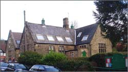
Hathersage Primary School (Alistair Cook)
Several private schools were opened up at this time, but in 1858 a National School opened in the village as an all-age school. This school, still using the original building, recently celebrated its Sesquicentenary with an exhibition and Victorian Day for the children.
Carriage travel and improved toll roads opened up the rural areas to the wealthy townspeople, who flocked to see the wonderful scenery. After the advent of the railway in 1894 and with the popularity of the bicycle, Hathersage was easily accessible to virtually anyone regardless of income. Hotels, boarding houses and cafes sprang up and local residents offered afternoon teas – or even hot water if you brought your own tea.
20th Century and beyond
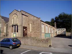
Hathersage Memorial Hall (Alistair Cook)
Many facilities have been added to the village during the last 100 years to make Hathersage a most enjoyable place to live in. The village boasts a large Memorial Hall which is used by many groups and organizations, and which was built by public subscription after the First World War. The King George V Playing Field is appreciated by the youngsters of the village as is the open-air heated swimming pool, one of only a few surviving in the country. This extremely popular with young and old as it is heated to a very comfortable temperature.
The years have rolled by, agriculture and industry have dramatically reduced or have been replaced by modern technology, but happily the village still retains it character – and its characters.
This short item is intended only to give you an idea of the history of Hathersage. There are many books relating to Hathersage history, some solely about the village, some about the surrounding area. Of special interest, and in alphabetical order, are:
An Accessible Wilderness. Jenny Elgar. Life at Stanage and the North Lees Estate. Recollections of life in the area.
Hathersage. A Guided Walk. Hathersage Environment Group. A guided walk around the village of Hathersage in the Hope Valley in leaflet form.
Hathersage – Images of the Past. Stella Maguire, Heather Rodgers, Jane Stone and Barbara Wilson. A unique photographic record of a village and its people.
Hathersage in the Peak. Barbara Buxton. An in-depth history.
Hathersage Remembers. Bob Dawson and Ryland Clendon. Memories of the village and its life, recalled by local residents.
Hathersage Reviewed. Michael Shuttleworth, May Ainsworth, Graham Bungard, Sue Clendon, Richard Jenkins, Dave Jenner and Brian Ward. A snapshot of a Derbyshire village in the Year 2000. Domesday Book II
Hathersage St Michael’s Church of England Primary School 1858 -2008. The first 150 years. Hathersage Church School Governors. A pictorial record of school life with reminiscences from former pupils.
The First Hundred Years 1894 to 1994. Neil Fletcher. Compiled from the original documents and minute books of Hathersage Parish Council.
The Peak District – Landscapes through Time. John Barnatt and Ken Smith. An introduction to the archaeological remains of the Peak District including early history, farming, quarrying and industry.